

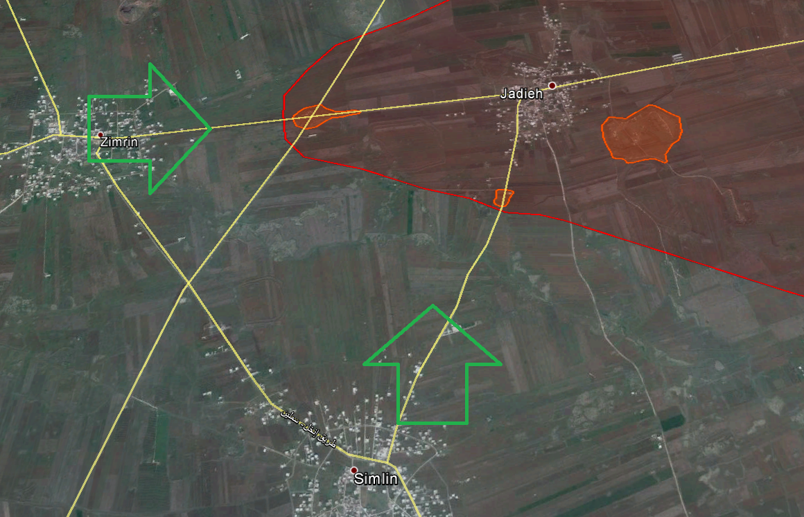
Después del impasse en el frente Sur, los rebeldes lanzaron un ataque desde diferentes direcciones que parecen converger sobre Judayyah y Qeita. Al Sur de Kfar Shams, el FSA y JAN sorprendieron con un coordinado y exitoso ataque contra la barrera ubicada en el camino Kfar Shams-Qeita, mientras que desde Zimirim y Similin se esta atacando a la barrera Oeste de Judayyah y a la base de artillería, al Sureste de este pueblo.
Los pueblos de Judayyah y Qeita son de extrema importancia, ya que pertenecen a uno de los tres ejes por donde los rebeldes pueden cortar la ruta Damasco-Daraa. En el eje Zimirim-Judayyah-Qeita-Izra, se ubican las bases de las divisiones 5° y 9°. Los otros ejes son Inkhil-Al-Qaniyah-Tubnah-Khabab, apenas al sur del primero, mientras que en el restante, Sheikh Miskin-Dhunaibah-Izra, se encuentra la base de la 12° Brigada y es quizás el más guarnecido por el régimen.
JAN y FSA atacando la barrera Kfar Shams-Qeita
[youtube]QndO00EdCWc[/youtube]
Los ataques sobre las barreras de Judayyah
[youtube]2cmDqP_LAV4[/youtube]
[youtube]EI3nyeQigUY[/youtube]
http://wikimapia.org/#lang=es&lat=33.08 ... 7&z=13&m=b
Continuando con Daraa, tras la conquista de Nasseb, los rebeldes han tomado todos los chekpoints que guarecían la frontera con Jordania.
[youtube]0edv-arDXQA[/youtube]
Respecto a Yarmouk, el Frente Islámico acudió en auxilio del FSA y grupos palestinos, por lo que parece que están contraatacando al ISIS y a los ex JAN.
[youtube]VyabSAgcua0[/youtube]
En cuanto a la situación en el desierto de Homs, las fuerzas rebeldes pertenecen a un combinado del FSA y Frente Islámico. En algun video se puede ver al FI atacando a ISIS, el cual no subo por ser gráfico.
Saludos!.
Guerra Civil Siria
-
Wallas

- Suboficial Primero

- Mensajes: 612
- Registrado: 26 May 2003, 18:01
Guerra Civil Siria
Última edición por Wallas el 07 Abr 2015, 02:07, editado 2 veces en total.
I love the smell of napalm in the morning. - Lieutenant Colonel William "Bill" Kilgore, 1st Battalion, 9th Air Cavalry Regiment.
-
Wallas
- Suboficial Primero
- Mensajes: 612
- Registrado: 26 May 2003, 18:01
Guerra Civil Siria
En Alepo estallaron combates en distintas zonas. Los rebeldes atacaron con bastante fuerza las proximidades del aeropuerto.
[youtube]scsS5_7gvxg[/youtube]
[youtube]nTIFN-1LoYc[/youtube]
http://wikimapia.org/#lang=es&lat=36.19 ... 9&z=15&m=b
En el Norte parece que también hay movimiento del lado rebelde. Mientras el Frente Islámico se encuentra machando Bashkuy y Handarat, el FSA busca profundizar en dirección a la prisión.
[youtube]97Hz0vhUABM[/youtube]
[youtube]VQ-xWSWwUGU[/youtube]
A propósito, en esta zona se esta haciendo uso de un novedoso cañón cuádruple, que parece ser una versión "avanzada" del bitubo.
El curioso artefacto bombardeando Bashkuy
[youtube]7s8HcJh8EIg[/youtube]
Aquí la presentación del mismo, hace aproximadamente un mes
[youtube]VcYl_L7ZUBo[/youtube]
Cambiando de tema, los rebeldes están atacando con bastante énfasis el pequeño pueblo de Hamamiyat,
en Hama. Este pueblito forma parte de la linea del frente de Hama y quizás su importancia este en que se encuentra a un flanco de Morek (con Kfar Zita de por medio).
[youtube]24QNbQC8_hE[/youtube]
[youtube]JhsyUdJe7Ws[/youtube]
[youtube]pUf_peWhesM[/youtube]
http://wikimapia.org/#lang=es&lat=35.38 ... 5&z=14&m=b
En cuanto a Maostuma, se va confirmando que el régimen ha subido la apuesta, reforzando toda la zona. En la siguiente grabación se muestran a las tropas de refuerzo en camino a Maostuma, me permito dudar de la veracidad del mismo, ya que muchas veces se han visto videos de convoyes del régimen aquí y allá, que resultaban ser de años anteriores.
[youtube]sbhVH3XZ3Zs[/youtube]
Saludos!.
I love the smell of napalm in the morning. - Lieutenant Colonel William "Bill" Kilgore, 1st Battalion, 9th Air Cavalry Regiment.
-
Ismael

- General

- Mensajes: 20343
- Registrado: 28 Ene 2003, 13:20
- Ubicación: Por ahí.

Guerra Civil Siria
Falta uno una semana, y hay que ver lo que pasa 
Bueno, mapas de la situación en el sur: eje Judayyah-Qeita (o Jadieh-Qiytah, según quién lo escriba)
Geolocalización del frente a partir de un vídeo:
[youtube]MguK8G-L8l8[/youtube]

Y un caza alcanzado por un MANPADS, se supone que por la misma zona; es un montaje de al menos dos grabaciones diferentes:
[youtube]czlhFRKUsx4[/youtube]
Un saludo
PD: Según el Telegraph, hasta un tercio de los alauitas sirios en edad militar habría muerto ya en la guerra:
http://www.telegraph.co.uk/news/worldne ... Assad.html
Bueno, mapas de la situación en el sur: eje Judayyah-Qeita (o Jadieh-Qiytah, según quién lo escriba)
Geolocalización del frente a partir de un vídeo:
[youtube]MguK8G-L8l8[/youtube]
Y un caza alcanzado por un MANPADS, se supone que por la misma zona; es un montaje de al menos dos grabaciones diferentes:
[youtube]czlhFRKUsx4[/youtube]
Un saludo
PD: Según el Telegraph, hasta un tercio
http://www.telegraph.co.uk/news/worldne ... Assad.html
Si Dios me hubiere consultado sobre el sistema del universo, le habría dado unas cuantas ideas (Alfonso X el Sabio)
Debemos perdonar a nuestros enemigos, pero nunca antes de que los cuelguen (H.Heine)
Debemos perdonar a nuestros enemigos, pero nunca antes de que los cuelguen (H.Heine)
-
Ismael
- General
- Mensajes: 20343
- Registrado: 28 Ene 2003, 13:20
- Ubicación: Por ahí.
Guerra Civil Siria
Y otro: éste de Yarmouk y alrededores.
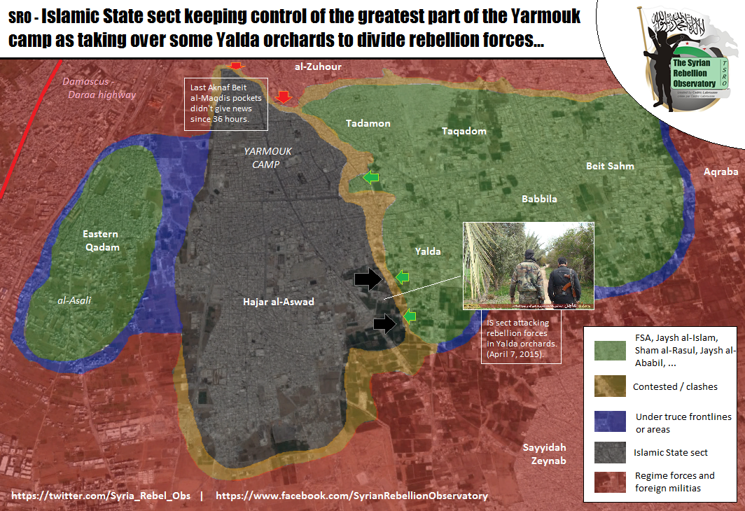
La tal Aknaf Beit al-Maqudis que aparece al norte del campo es la milicia palestina local que se ha enfrentado al ISIS: aunque ahí diga que llevan 36 horas sin dar señales de vida, de hecho, sacaron ayer un comunicado:
https://pbs.twimg.com/media/CB_v1YtWMAA0wMl.jpg
Está en árabe, claro. Dicen que acusan a otros grupos palestinos de haberse unido al ISIS, y a JAN de haberles dejado entrar en el campo el día antes del ataque.
No son los únicos que defienden la misma acusación
http://www.elmundo.es/internacional/201 ... b4575.html
Un saludo
Si Dios me hubiere consultado sobre el sistema del universo, le habría dado unas cuantas ideas (Alfonso X el Sabio)
Debemos perdonar a nuestros enemigos, pero nunca antes de que los cuelguen (H.Heine)
Debemos perdonar a nuestros enemigos, pero nunca antes de que los cuelguen (H.Heine)
-
Rebelde!
- Comandante

- Mensajes: 1597
- Registrado: 25 Ago 2012, 18:54
- Ubicación: Santiago, Republica Dominicana

Guerra Civil Siria
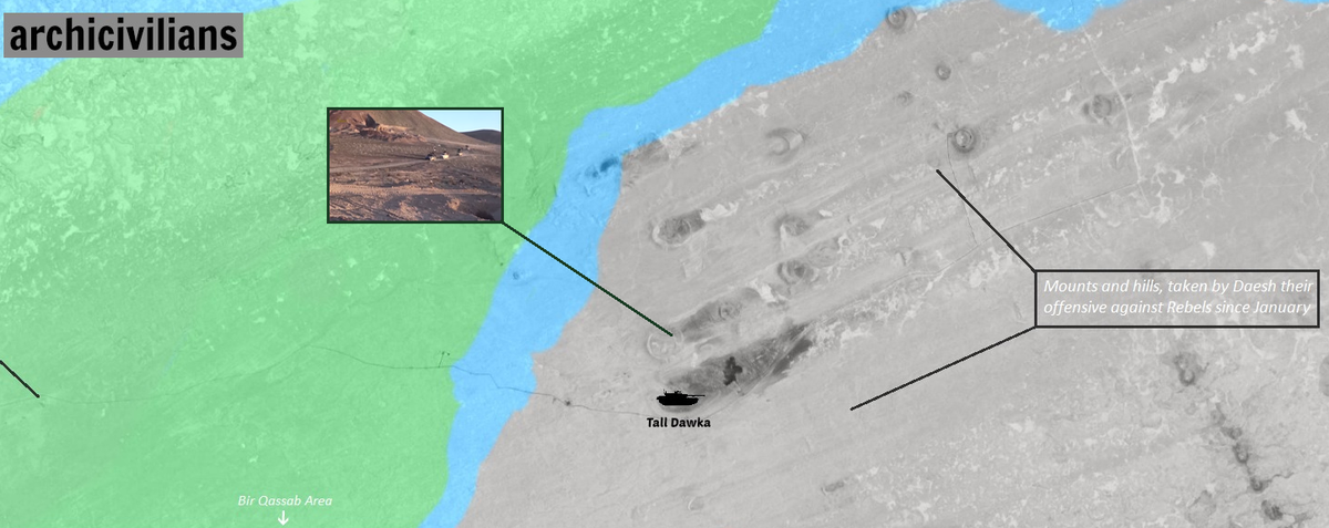
Saludos, algo o algún grupo le esta dando fuerte dolor de cabezas a los ESOS en la zona desertica de siria. 

El Estado Islámico excava un gigantesco foso en Siria para protegerse de un enemigo desconocido
http://www.abc.es/internacional/2015040 ... 90850.html
El grupo terrorista está vaciando una franja de terreno de 70 kilómetros en el noreste de Siria para evitar los ataques de un grupo desconocido que está sembrando el caos entre sus filas.
-
Ismael
- General
- Mensajes: 20343
- Registrado: 28 Ene 2003, 13:20
- Ubicación: Por ahí.
Guerra Civil Siria
Rebelde! escribió:El Estado Islámico excava un gigantesco foso en Siria para protegerse de un enemigo desconocido
http://www.abc.es/internacional/2015040 ... 90850.html
Supongo que se refieren a "La Mortaja Blanca"
http://www.elconfidencial.com/mundo/201 ... as_458040/
Por otro lado:
el portavoz de la Red «Deir al Zur 24», Rami al Hakim, señala que cada 15 kilómetros hay un cruce para poder pasar de un lado a otro, y que algunos de los tramos están controlados por milicianos yihadistas.
¿Milicianos en posiciones fijas a lo largo de una línea bien visible desde el aire? Por algo hay aquí quien les llama "los imbéciles"
Un saludo
PD: También en el ABC, las pésimas condiciones higiénicas en el "territorio ISIS" provocan una epidemia de leishmaniasis; se estiman 100.000 contagiados ya:
http://www.abc.es/internacional/2015040 ... n=obinsite
Si Dios me hubiere consultado sobre el sistema del universo, le habría dado unas cuantas ideas (Alfonso X el Sabio)
Debemos perdonar a nuestros enemigos, pero nunca antes de que los cuelguen (H.Heine)
Debemos perdonar a nuestros enemigos, pero nunca antes de que los cuelguen (H.Heine)
-
Ismael
- General
- Mensajes: 20343
- Registrado: 28 Ene 2003, 13:20
- Ubicación: Por ahí.
Guerra Civil Siria
Ahrar as Sham decide establecer una "oficina política" en Idlib (miedo dan)
[youtube]FZ7lGPapV_w[/youtube]
Interesante es que uno de esos barbudos que dirigen el cotarro en el vídeo es un tal Mohammed Shamouka, líder del Frente Islámico Kurdo, que se habría fusionado con HASI.
Y no sé cómo se llaman, pero las Batman éstas se supone que son una brigada jihadista femenina que ha decidido tomar como sede el monasterio de san Simón el Estilita (Patrimonio de la Humanidad, la parte más antigua es una iglesia del siglo V que aparece sobre la mitad del vídeo):
[youtube]YX4icBecwJU[/youtube]
https://en.wikipedia.org/wiki/Church_of ... n_Stylites
Un saludo
PD: En el "bando cristiano", milicianos asirios en el frente del río Khabour (Hasaka Occidental)
[youtube]I5HQEoXeLD0[/youtube]
Y un mapa del frente:
Si Dios me hubiere consultado sobre el sistema del universo, le habría dado unas cuantas ideas (Alfonso X el Sabio)
Debemos perdonar a nuestros enemigos, pero nunca antes de que los cuelguen (H.Heine)
Debemos perdonar a nuestros enemigos, pero nunca antes de que los cuelguen (H.Heine)
-
Ismael
- General
- Mensajes: 20343
- Registrado: 28 Ene 2003, 13:20
- Ubicación: Por ahí.
Guerra Civil Siria
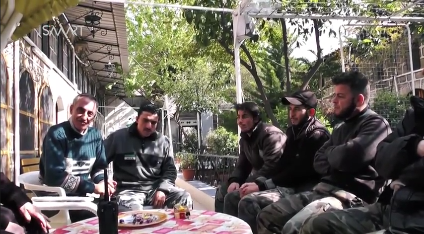
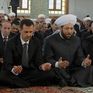
En contraste con las anteriores: representantes del Frente Islámico visitan la iglesia de San Elías de Alepo durante las celebraciones de la Pascua ... ¿llevan unos huevos de pascua de regalo?.
[youtube]eCz5ctDY-8M[/youtube]
Sólo un par de días después de la publicación del vídeo, parece que un bombardeo del régimen ha matado al párroco de la iglesia, Michel Oubaji (el de la izquierda de la foto):
Ambos bandos llevanvarios días bombardeándose mutuamente en ese área de la ciudad:
http://www.dailymail.co.uk/wires/ap/art ... ing-3.html
Un saludo
PD: Mapa actualizado del norte de Siria, desde el cantón kurdo de Efrin (tal vez lo más interesante es que parece que stán colaborando con el Frente de Levante).
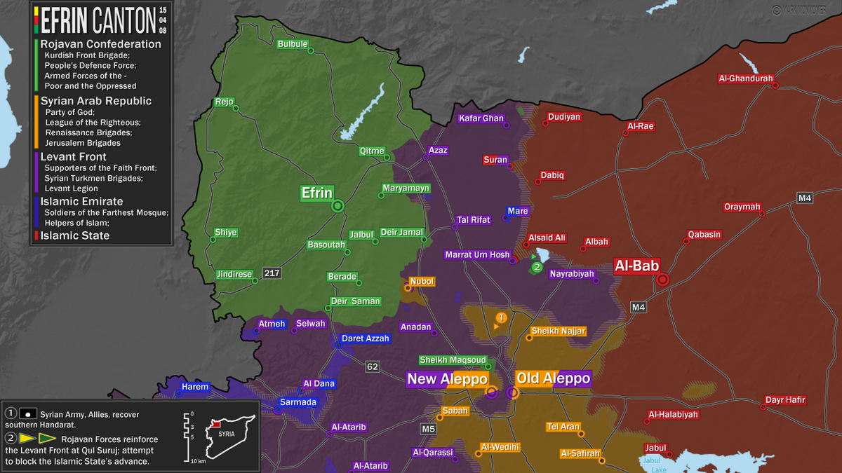
Ampliación:
https://354c7baf01869bc8b3e86b01aaeb53b ... -04-08.png
[youtube]eCz5ctDY-8M[/youtube]
Sólo un par de días después de la publicación del vídeo, parece que un bombardeo del régimen ha matado al párroco de la iglesia, Michel Oubaji (el de la izquierda de la foto):
Ambos bandos llevanvarios días bombardeándose mutuamente en ese área de la ciudad:
http://www.dailymail.co.uk/wires/ap/art ... ing-3.html
Un saludo
PD: Mapa actualizado del norte de Siria, desde el cantón kurdo de Efrin (tal vez lo más interesante es que parece que stán colaborando con el Frente de Levante).
Ampliación:
https://354c7baf01869bc8b3e86b01aaeb53b ... -04-08.png
Si Dios me hubiere consultado sobre el sistema del universo, le habría dado unas cuantas ideas (Alfonso X el Sabio)
Debemos perdonar a nuestros enemigos, pero nunca antes de que los cuelguen (H.Heine)
Debemos perdonar a nuestros enemigos, pero nunca antes de que los cuelguen (H.Heine)
-
Rebelde!
- Comandante
- Mensajes: 1597
- Registrado: 25 Ago 2012, 18:54
- Ubicación: Santiago, Republica Dominicana
Guerra Civil Siria
Saludos.
Retroceso para los ESOS en siria, los kurdos entran un poco mas a raqqa.
 alguien tiene mapa de este nuevo avance?
Combatientes kurdos avanzan en Raqa, bastión del ISIS en Siria
http://www.infobae.com/2015/04/12/17218 ... isis-siria
Retroceso para los ESOS en siria, los kurdos entran un poco mas a raqqa.
Combatientes kurdos avanzan en Raqa, bastión del ISIS en Siria
http://www.infobae.com/2015/04/12/17218 ... isis-siria
-
Ismael
- General
- Mensajes: 20343
- Registrado: 28 Ene 2003, 13:20
- Ubicación: Por ahí.
Guerra Civil Siria
Rebelde! escribió: alguien tiene mapa de este nuevo avance?
A mandar

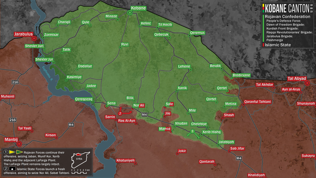
Ampliación:
https://354c7baf01869bc8b3e86b01aaeb53b ... -04-13.png
Y otro:

Ampliación:
https://pbs.twimg.com/media/CCearemWAAAO9LO.jpg:large
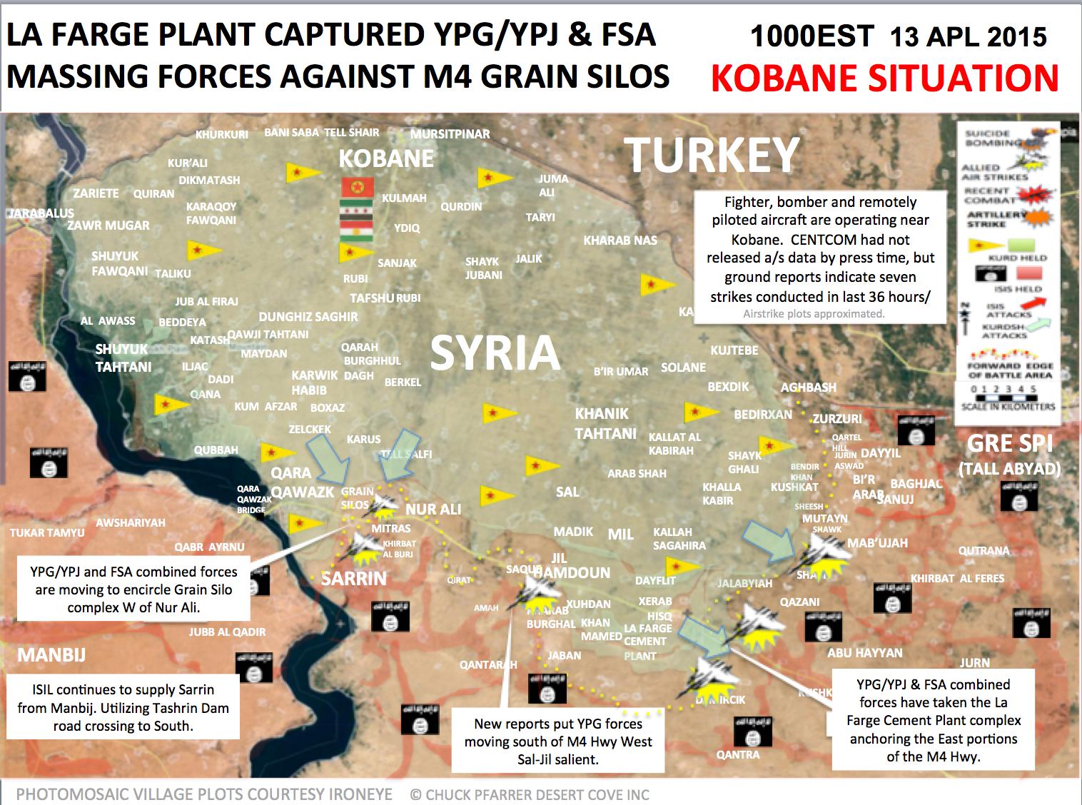
La fábrica de cemento que mencionan en el enlace es la tal "LaFarge" que sale en el punto 1 del primer mapa:
http://wikimapia.org/#lang=es&lat=36.54 ... 87214&z=15
Un saludo
Si Dios me hubiere consultado sobre el sistema del universo, le habría dado unas cuantas ideas (Alfonso X el Sabio)
Debemos perdonar a nuestros enemigos, pero nunca antes de que los cuelguen (H.Heine)
Debemos perdonar a nuestros enemigos, pero nunca antes de que los cuelguen (H.Heine)
-
Alberto Elgueta
- Teniente Primero

- Mensajes: 1160
- Registrado: 16 Oct 2007, 19:15

Guerra Civil Siria
¿Las fuerzas de Kobane no estarán abarcando demasiado con recursos limitados? Según los mapa parecen estar emprendiendo dos o tres ofensivas en paralelo hacia el sur.
-
Rebelde!
- Comandante
- Mensajes: 1597
- Registrado: 25 Ago 2012, 18:54
- Ubicación: Santiago, Republica Dominicana
Guerra Civil Siria
Eso depende de por ejemplo, la organización de los contendientes, la coordinación en sus movimiento, el apoyo recibido de una o mas fuentes y que los kurdos cuentan con apoyo aéreo y artillería de tierra, lo kurdos luchan por sus vidas y los ESOS por una utopía falsa e inhumana. Ah otra cosa los ESOS la llevan mal ya que hasta están enrolando menores en sus filas 
-
Ismael
- General
- Mensajes: 20343
- Registrado: 28 Ene 2003, 13:20
- Ubicación: Por ahí.
Guerra Civil Siria
Habría que ver cómo de permeable es la frontera turca. Es posible que el enclave esté recibiendo nuevos recursos (incluyendo combatientes del ELS) que les permitan abarcar nuevos territorios.
PD: Otro mapa: el este de Damasco
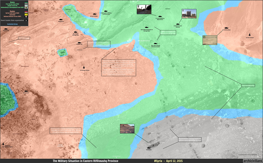
Habría una ofensiva rebelde en este área:
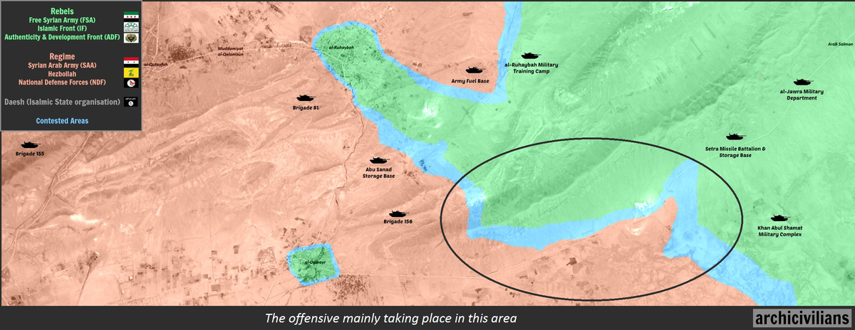
Según la ampliación del mapa general, rebeldes habrían tomado el control de la carretera Damasco-Bagdad en varios puntos de la zona, y las colinas que la dominan en otros; sin embargo, habría un acuerdo para permitir cruzarla a convoyes gubernamentales, a cambio éstos respetan a los pueblos rebeldes más al oeste:
https://archicivilians.files.wordpress. ... dumayr.png
Y más al sur, hace su aparición el ISIS, aunque parece que no ha llegado a cortar la ruta de abastecimiento rebelde:
Un saludo
PD: El gran mufti de Siria, Ahmad Hassoun, prorrégimen, publica una fatwa donde insta a "aniquilar" los barrios de Alepo donde operan rebeldes, estén poblados o no:
http://www.doamuslims.org/?p=2638
http://www.dailystar.com.lb/News/Middle ... leppo.ashx
El susodicho:
Hay por ahí algún vídeo con declaraciones del mismo en TV gubernamentales, pero en árabe, claro.
Un saludo
PD: Esto se supone que es una bomba de barril cargada con cilindros de gas cloro que no explotó:
https://vid.me/stbC
PD: Otro mapa: el este de Damasco
Habría una ofensiva rebelde en este área:
Según la ampliación del mapa general, rebeldes habrían tomado el control de la carretera Damasco-Bagdad en varios puntos de la zona, y las colinas que la dominan en otros; sin embargo, habría un acuerdo para permitir cruzarla a convoyes gubernamentales, a cambio éstos respetan a los pueblos rebeldes más al oeste:
https://archicivilians.files.wordpress. ... dumayr.png
Y más al sur, hace su aparición el ISIS, aunque parece que no ha llegado a cortar la ruta de abastecimiento rebelde:
Un saludo
PD: El gran mufti de Siria, Ahmad Hassoun, prorrégimen, publica una fatwa donde insta a "aniquilar" los barrios de Alepo donde operan rebeldes, estén poblados o no:
http://www.doamuslims.org/?p=2638
http://www.dailystar.com.lb/News/Middle ... leppo.ashx
El susodicho:
Hay por ahí algún vídeo con declaraciones del mismo en TV gubernamentales, pero en árabe, claro.
Un saludo
PD: Esto se supone que es una bomba de barril cargada con cilindros de gas cloro que no explotó:
https://vid.me/stbC
Si Dios me hubiere consultado sobre el sistema del universo, le habría dado unas cuantas ideas (Alfonso X el Sabio)
Debemos perdonar a nuestros enemigos, pero nunca antes de que los cuelguen (H.Heine)
Debemos perdonar a nuestros enemigos, pero nunca antes de que los cuelguen (H.Heine)
-
Eldrig
- Cabo Primero

- Mensajes: 157
- Registrado: 13 Feb 2013, 00:49
Guerra Civil Siria
¿Ese gran Mufti es sunita?...
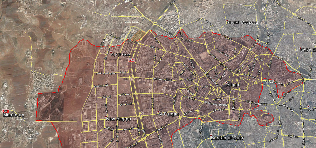
En otras noticias, los rebeldes finalmente toman el Edificio de Inteligencia de la Fuerza Aerea al oeste de Aleppo, lo hicieron mediante la explosión de un tunel bomba (algo que ya va siendo especialidad en el bando rebelde, pues al mismo tiemp se reporto de otro tunel bomba en el centro de Aleppo), y ahora al parecer sí lo han tomado, pues hace un par de meses también lo intentaron por el mismo medio pero fallaron después al intentar tomar el edificio, no como ahora que lo que queda del edificio ya estaría bajo control rebelde... y aprovechando el impulso se han dirigido hacía el barrio de Zahra (no confundir con el enclave chiíta al norte de Aleppo).
https://vid.me/inu5
El edificio tomado estaría en el color amarillo, más abajo está Zahra:
En cuanto a Idlib, las fuerzas al mando del coronel Tigre (ahora ya se ha confirmado su llegada a la zona) está intentando tomar Qmeinas al sur de Idlib, sin embargo no ha tenido éxito de momento pero aún mantendrían la fabrica de ladrillos un poco más cerca de Mastouma... Lo que sí es efectivo, es que la ofensiva lanzada por los rebeldes para tomar Mastouma hace una semana atrás no dió resultado y actualmente todo el pueblo estaría bajo control de fuerzas lealistas.
Por último algo importante respecto al frente sur (Daraa), allí dos milicias del FSA han hecho una declaración para distanciarse de Al-Nusra, sin embargo, se desmiente que hayan habido combates entre ambas facciones como algunos medios sostienen.
Saludos.
-
Eldrig
- Cabo Primero
- Mensajes: 157
- Registrado: 13 Feb 2013, 00:49
Guerra Civil Siria
Pongo una entrevista interesante a un general de Ahrar al Sham sobre la toma de Idlib:
El mes pasado, una coalición de grupos rebeldes capturaron Idlib en el noroeste de Siria después de una ofensiva de cuatro días. La capital provincial es la tercera perdida por el régimen de Assad en el conflicto sirio desde cuatro años, pero el primero en ser gobernado por la oposición - Raqqa está en manos del Estado islámico y Quneitra se despobló.
El reporte distorsionado de los grandes medios de comunicación acerca de Idlib afiraban que Jabhat al-Nusra había tomado el control de la ciudad; de hecho, la facción islamista ni siquiera era el grupo más grande de la coalición rebelde. Sin embargo, las afirmaciones de "extremistas" plantearon desafíos políticos: La tergiversación de los medios de comunicación se suma al reto político para la oposición, quizás el más grande en los cuatro años de conflicto. Los grupos que ahora tratan de reestablecer los servicios básicos en Idlib han de mostrar la capacidad de gobernar en lugar de luchar entre sí, implementando un sistema legal y social que se preocupe más de la protección de las vidas y los derechos de los civiles en lugar de someterlos al castigo y amenaza del bombardeo del régimen.
Abu al-Yazid Taftenaz de Ahrar a-Sham, la facción más grande de la coalición, habla desde Siria sobre los planes para el gobierno y administración de Idlib:
Q: Algunos activistas de la oposición han expresado su preocupación de que el destino de la ciudad de Idlib pueda ser similar a la de Raqqa y Deir ez-Zor [zonas de fuerte presencia del Estado islámico]. ¿Cuáles son algunos de los factores que podrían mitigar esa posibilidad?
Las brigadas rebeldes están de acuerdo unos con otros, y han formado una sala de operaciones unida que goza de un alto nivel de cooperación en el trabajo militar.
Nos pusimos de acuerdo, en la sala de operaciones, de entregar la ciudad a la administración civil, y el papel de las brigadas rebeldes será limitarse a la protección de la ciudad.
En cuanto al repetido bombardeo de la ciudad, no podemos tomar el control de esa situación a causa de los aviones de combate del régimen. Lo que estamos viendo en términos de desplazamiento es el resultado del bombardeo continuo sobre la ciudad.
Q: Después de que Idlib fue liberada, la bandera de la revolución flameo junto a la bandera de Jabhat a-Nusra y de otras brigadas. ¿Cuál es el mensaje detrás de izar la bandera revolucionaria dentro de la ciudad?
En cuanto a las brigadas militares, cada brigada tiene su propia bandera. Nadie impide que cualquier persona pueda levantar su bandera, las brigadas están abiertas, en la medida de lo posible, a todos. Pero hay una condición: que las brigadas no actuen de una forma independiente de las otras brigadas de la sala de operaciones.
Al final del día, las decisiones de la sala de operaciones del Ejército de la Victoria son para beneficio de la gente.
Q: El Observador Asirio acusó a las brigadas de la oposición de matar a un hombre cristiano y a su hijo en la ciudad. El Ejército de la Victoria anunció que aseguró un camino para la salida de 20 familias cristianas en función de su deseo de irse. ¿Cómo están tratando con los civiles que estaban bajo el control de régimen en la ciudad, y los cristianos en particular?
En general, si no hay una indicación de que una persona es un agente del régimen o Shahiba, será tratado como cualquier civil igual que en el resto de las zonas liberadas. Para su información, hay algunas personas con malos antecedentes, pero siempre y cuando no haya ninguna prueba de [su participación colaborando con el régimen] no serán tratados de manera diferente. Un civil es un civil.
En cuanto a los cristianos, el jeque al-Moheisini [un clérigo líder de los rebeldes] dice que si quieren vivir entre nosotros están en su derecho. No podemos imponer la jizya (impuesto no musulmán) a ellos. Luego, el cristiano vivirá como cualquier otro civil en la ciudad de Idlib.
Q: Alguien cercano a Ahrar-Sham escribió que en una reunión a nivel de líderes del Ejército de la Victoria, se formó un consejo de administración unificada para la ciudad de Idlib con el fin de facilitar los asuntos de los civiles de la ciudad. ¿La ciudad se va a regir bajo la ley militar, o por la ley civil?
En cuanto a la administración, de acuerdo con el jeque Abu Jaber, líder de Ahrar-Sham: "Nuestro objetivo no es la administración de la ciudad, y la ciudad será entregada al gobierno civil." Nuestro objetivo es proteger a los ciudadanos, incluso de la aviación militar a pesar de la falta de cañones antiaéreos. Las brigadas rebeldes en especial, deben permanecer en la ciudad, por temor a que el régimen trate de tomarla de nuevo.
Quiero subrayar una vez más que las brigadas rebeldes no se comprometen a administrar la ciudad. Por el contrario, la administración está a cargo de civiles: Eso fue lo acordado en los mandos del Ejército de la Victoria.
Q: En Raqqa silenciosamente se han publicado noticias de que los miembros de la Hisbeh [policía religiosa del Estado Islámico] anunciaron que el Estado Islámico logrará una victoria, pronto, en Idlib. ¿Qué medidas están tomando para evitar que la ciudad caiga en sus manos?
Ellos no van a tener suerte en Idlib. Su presencia está muy lejos de la ciudad, teniendo en cuenta que tienen algunas áreas de control en el campo oriental Idlib. En las áreas de Idlib, si Dios quiere, no se verá ninguna presencia del EI.
Q: ¿Cuáles son los planes o medidas futuras de Ahrar a-Sham en la zona con el fin de obtener el apoyo de la población civil?
Hay un lema, "Ahrar a-Sham es una revolución del pueblo." Lo que diferencia a Ahrar-Sham es que sus combatientes son Sirios, creo que el porcentaje de extranjeros no es más que el 1% del movimiento. Teniendo en cuenta que los combatientes del movimiento son los hijos de Siria, esto nos hace cercanos al pueblo sirio y sus aspiraciones.
¿Quién está conectado?
Usuarios navegando por este Foro: ClaudeBot [Bot] y 19 invitados